Tuesday, September 17, 2013

Mt Graham 15th September

I'd initially planned to have a rest day and ride Mt Graham the next day. 


Legs were surprisingly feeling okay and there were some showers which kept the morning a little cooler, so I pulled into the Prison car park that is at the base of the Mt Graham and set off up the climb.


This was a climb I didn't find much information about other than it was worthwhile to include in the itinerary, therefore didn't know the gradient or length. With the climb starting below 4000 feet, the air was like soup and even with fatigued legs power was back to where I'd I'm used to seeing it!


The climb started with a straight run through arid low scrub and then wove into the hills above. Initially dry slopes and then into pine forests. It did vary gradients though nothing too steep and was a wonderful climb as it made its way up the mountain. 


At Ladybug saddle, the road cut onto the other side of the mountain with views toward Tucson. Shortly before the road turned to gravel and the end of my climb I passed sign noting the elevation of 9,000 feet. 


A couple of weeks ago that would have been a struggle, after the riding over these weeks meant I could enjoy the last kilometres to its end.


Unfortunately the surface wasn't the best with gravel on many of the corners. Therefore it was a more cautious descent back to the van.


In my investigations about the climb I'd read to park in the visitors car park at the prison. The prison guard who drove up as I loaded the van was reasonable especially on hearing my accent, but they definitely don't like people parking there as many people try to throw contraband over the fence so don't like unknown vehicles. I was told they rather cyclists park a little up the road and on the opposite side.


I drove a short way to the Roper Lake State park where I planned to spend the night. This is a gem. $15 for the night, showers, lake for swimming and even a natural hot spring in the grounds!


After a swim in the lake, I drove into town to a laundromat do do some washing and headed back for another swim! Unfortunately with all the water around there were numerous mosquitoes, so I retreated quickly to the still hot van and had an uncomfortable nights sleep.

Ride details: distance 67.44km Maximum elevation 2799m

2113m elevation

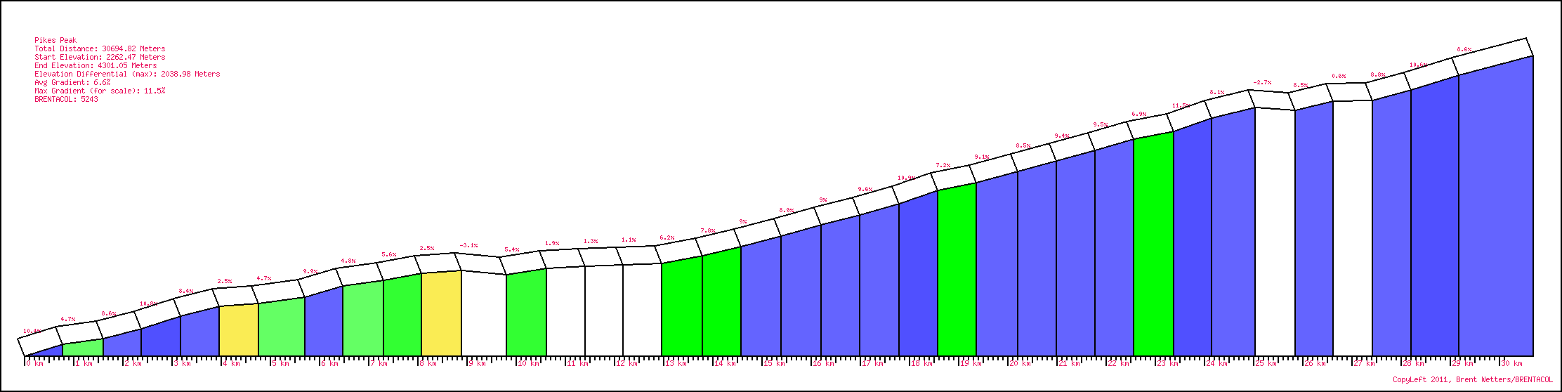
Pikes Peak 14th September

It was only a short drive downhill before I'd parked by highway 24 and the start of the road to Pikes Peak. Once rolling, It wasn't long and I was already into my lowest gear and I hadn't even made the entrance station!


This was the first year bikes have been allowed on the climb year round after a successful trial last September. So I gladly paid my $12 and was onto the climb proper. It ascended in steps with the steeper sections fortunately followed by easier sections where I could recover. Low down the altitude was not yet an issue.


It was around Glen Cove where the road kicked up again via a series of hairpins and it got hard again. It was steep and meant I had to work hard to keep the bike moving! Finally the angle relented and the road wove around the rocks named the Devils Playground due to the way lightning dances around them. Although there were a few menacing clouds, luckily the weather was holding.


The summit was in sight, but once again the gradient kicked up. My gearing incorporated a mid cage derailleur so I could use a 13-29 cassette had been fine up until now on all my travels. The problem was at this altitude studies show you can only produce around 72% of your sea level power and at that power I could barely turn the pedals on this section! My cadence was sitting as low as 45 rpm and any time I tried to push even a little above this substantially reduced wattage, I'd spend the next minute trying to recover!

The summit did thankfully finally arrive; the top the complete opposite of Mt Evans as it was swarming with cars and people! I did there discover how to be a minor celebrity; have a bike around the viewing platform. I was asked numerous times incredulously if I'd ridden my bike all the way up and even had photos taken including group shots. I even got asked if I was a professional cyclist! They obviously must have arrived just after me, as if they saw me chewing the bar tape with a distant, tortured expression on the climb that wouldn't have been asked!


On the way up I'd given up trying to take photos, as I would hold my breath whilst taking the photo to keep steady and again gasped for breath afterwards. So on the descent I stopped for a few more photos of the scenery and then continued down to the van.

I cleaned up as best as I could, got my food organised and then set the GPS. It was going to be the longest driving leg of the trip; from Colorado Springs to just short of Tucson Arizona – 1200 km!
As I left the outskirts of Colorado Springs the rains returned! So other then the freezing rains on the Eastern side of the Trail Ridge Road, I was leaving Colorado relatively unaffected by the horrific flooding that has hit the state over the last couple of days.

Interstate cuts a swath straight South through Colorado and then New Mexico. I stopped briefly at a road stop still in Colorado to brew a coffee and then at Santa Fe New Mexico for gas; otherwise didn't stop till just short of Deming where the road hits I10 and pulled the van off the road at 11pm. Nine hours driving with still a few tomorrow to finish the journey...

Ride details: distance 64.08km Maximum elevation 4,301m


2,226m elevation


Mt Evans 13th September

My eyes were glued to the various weather channels late into the night and again first thing in the morning. It was still raining in Idaho Springs, but one channels forecast for the day was showing the showers scattering from 9am; this was the forecast I was banking on!

It had stopped raining when I finally left the hotel just prior to 9am and drove closer to the climbs start to get ready. Some roads here in town were closed with workers clearing gravel and rocks washed across the road from the last 24 hours of rain. So even if the rain stopped, there still may be a chance the road will be blocked. I decided I'd try and go as high as I can and if I have to turn around I've at least tried. 


The lower half of the road from Idaho Springs to Mt Evans mostly followed a narrow valley, with a creek and road swapping sides. 


The creek was still well in flood with a huge amount of water overflowing its banks. From various side tracks,water was rushing across the road and also covering it with gravel. I made my way carefully upwards as the sun even started to make an appearance. It looked like the forecast may indeed be right!


There was a steady stream of traffic coming downhill; one motorist slowed and asked my if the road was open to Idaho Springs. Fortunately the blockage she was coming from was above the turnoff at Echo lake which I reached soon after and marked the halfway point. 


Just as I turned onto Mt Evans road, there was a huge grader coming down on my side of the road. I stopped and spoke with the driver; he told me he had just cleared a blockage to let cars down from Summit Lake and was about to lock the lower gate we were adjacent to. He warned that I would be on my own from here so to be wary!


It was a little eerie but also a unique experience having the mountain to myself. I always knew the road above Summit lake would be closed to cars (closes Labor Day weekend in September) but not all the way from Echo Lake.


As I started to clear the tree line, the Marmots would dart across the road and under rocks. Their warning shrieks the only sound other than my laboured breathing. Given the road was never steep, I was still feeling okay as I approached Summit Lake which marked the last 8km push to the elusive summit.


Just before the gate a Rangers car passed me and stopped. I was worried that I had come so close and I may not be able to complete my ascent! He was looking for a herd of Mountain Goats and had no qualms with me continuing. So I rode to the gate and carefully ducked underneath. 

The weather still holding, though the summit was shrouded with cloud meaning I couldn't see far ahead and where the finish was. All I could do was focus on my breathing and pedaling and count down the distance remaining. 


After 44 km of climbing, I finally turned the last hairpin and made the summit car park; I'd made it! The highest paved road in the North America at 4,315 metres.


It was freezing, with some remnants of last nights snow still clinging in a few crevices. I took quite a few photos and then started my descent. The road wasn't in great condition, but knowing there was only the rangers car below meant I could take the best line.


The rest of the descent was enjoyable, especially once I started to get lower and and the air warmed. It was a huge relief to have been able to ride Mt Evans after yesterdays flooding across much of the area. One of the prize climbs I had thought I may not be able to ride.

Even Colorado Springs at the base of Pikes Peak hadn't escaped the heavy rains and there were quite a few road closures and detours when I made my way to friends who live just above the city. Here I was able to spend an enjoyable evening with a view of Pikes Peak from their living room window! Even from here at over 8,000 feet, the mountain dwarfed all that surrounded it.

Pikes Peak would be my last Colorado ascent in the morning. It is also over 14,000 feet and only 14 metres lower than Mt Evans, but although a fraction lower has a nasty reputation due to the steepness at altitude! At least the forecast was still improving.

Ride details: distance 90.5km Maximum elevation 4315m


2054m elevation

Friday, September 13, 2013

Trail Ridge Road 12th September

I woke at 6am wanting to be in the park and on the bike by dawn. This would mean I hopefully avoid the thunderstorms more frequent in the afternoons plus much of the traffic as possible that traverses this road.

It was a very short distance to the Entrance station and into the park. Unfortunately it was raining heavily, so I waited in the van hoping that it would ease. I had expected afternoon thunderstorms but I wasn't expecting rain in the morning.


Finally around 7:50am the rain did ease to a drizzle. That I could handle, so I quickly changed and was on the road only minutes later. 

The road on this side undulated for the first 15km and was a nice way to start the day. The early start has meant the traffic was light so could just focus on riding and the views. What was missing was the teeming wildlife I was expecting! I started to wonder it the rangers hadn't let them out yet for the passing tourists to see? After 9km, I finally spotted a small herd of Elk in the distance and then a kilometer later a herd of deer and lone Elk. For the day though that was pretty much it!


The western ascent is a long one at over 35.5 km including the easy start and it took some time to clear the treeline. It was cold up here, but I'd spent much of winter training in the hills back home in similar conditions so wasn't too uncomfortable... yet. 


Pity the visibility was so poor as I have read it is beautiful. A few glimpses were possible through the clouds so got to experience a little of it myself.


Near the top the rain returned. As I didn't see a sign noting the high point of 12,183 feet and not knowing exactly where the highpoint was, I continued further. If I did know though, I would most likely have turned around due to the freezing wind that also now accompanied the rain.  

A few kilometers later when the undulations ended, I figured the top must now be behind me so might as well continue. In hindsight I still should have turned, as the heavy rain and windchill from the descent had me shivering uncontrollably! I finally pulled the pin at the entrance to Falls road only 3km from the Falls Road entrance station which was my planned turn around. Here a concerned motorist actually pulled over and asked if I wanted a lift, but as I was soaked through and freezing, the only way I could see myself warming up was to climb!
This worked to a degree except my hands and feet that were soaked through! Eventually I made it back over the top (confirmed there was no marker denoting this) and down the western side. On this side there was even a few flashes of sun! The warmth was a blessing as I was shivering again and with hands so cold it was hard to brake.


The descent would have been another enjoyable flowing descent if I wasn't frozen. At least at the bottom the sun was fully out and the roads dry so managed to warm a little at last. 

I changed immediately on returning to the van and once feeling returned to my fingers and toes I loaded the van and set off to Idaho Springs at the base of Mt Evens; my objective for the morning.

At the hotel, I switched on the TV and found out the extent of the rain and flooding that was all over the front range. It also explained why there was more traffic heading west; Estes Park was completed flooded and Trail Ridge road was the only way out of town! Some were saying today was the one in fifty or even one in one hundred year flood with rain and flooding continuing into tomorrow! Optimistically I am look at the reports and imagine Mt Evans will be relatively dry.

Ride details: Distance 127.43km Max elevation 3713m


2448m elevation


Leadville to Grand Lake - driving 11th September

Wake to a cold and wet day. Fortunately today is one of the few rest days I have given myself and is only a transit day to Grand Lake.

From here I plan on riding up Trail Ridge Road in the Rocky Mountains National Park. It is said to be one of the most scenic roads in Colorado and as an extra incentive tops out at 12,183 feet.

After doing one more load of washing and generally procrastinating, I packed up the van and made my way into town to finally buy some stamps and postcards. Will be interesting to see if the cards or I arrive first...

The drive to Grand Lake took in Freemont pass which I struggled up yesterday and I feel a little better as the climb was as bad as I remembered. The rest of the drive via Kremmling took in some lovely vistas of mountains and rolling farmland.


I drove straight to the Kawuneeche visitor centre at the Grand Lake entrance to Trail Ridge Road just see if I can leave the van there in the morning and find out relevant details about road conditions and entry costs. Ranger at the counter was a little concerned when I told her my plans, as it was currently only a few degrees above zero with visibility down to 40 metres at the top. Unfortunately this weather will be around till the weekend at least so looks to be the same tomorrow. At least I was forewarned about the conditions and immediately unpacked the merino undershirt and all my winter kit plus the lights for my bike.

Once I had the information I needed, I drove back through the town of Grand Lake – all full of gaudy tourist trinkets so I continued straight to the Stillwater campground located on the shore of Lake Granby where I will stay the night. All a little exposed after all the trees had to be removed due to Pine beetle. But has showers so more facilities than most park campsites.


To bed early with initially drizzle then rain falling heavily on the van...